Background
Flooding is Scotland’s costliest climate hazard and our biggest adaptation challenge. In the future our winters will be warmer and wetter, our summers hotter and drier, sea level rise will continue, and our weather will become more variable and unpredictable; extreme events such as storms and their associated impacts will become more common. Across Scotland many homes and businesses are currently at risk of flooding, and this will increase if insufficient action is taken to tackle climate change.
We are carrying out two phases of consultation to inform the development of the 2028 - 2034 Flood Risk Management Plans. Phase 1 is a community-focussed consultation and is your opportunity to tell us your flooding issues and priorities within Potentially Vulnerable Areas, to help shape these plans. We are also seeking information from you on projects and initiatives that are already happening to help manage flooding in Potentially Vulnerable Areas. This will inform the objectives and actions that will be proposed in the Phase 2 consultation.
Please note that these consultations do not cover all communities in Scotland. We would like you to answer the questions in relation to Potentially Vulnerable Areas only, as these will be the focus of the 2028 - 2034 Flood Risk Management Plans. We consulted on these areas as part of a public consultation process in 2024.
If you have any concerns about flooding in areas outwith Potentially Vulnerable Areas, we recommend contacting the responsible authority – you can find out more on responsible authorities on our website: Responsibilities for flooding.
Once the Phase 1 consultation closes, we will take time to consider responses and will use them to inform the Phase 2 consultation.
Flood Risk Management Planning
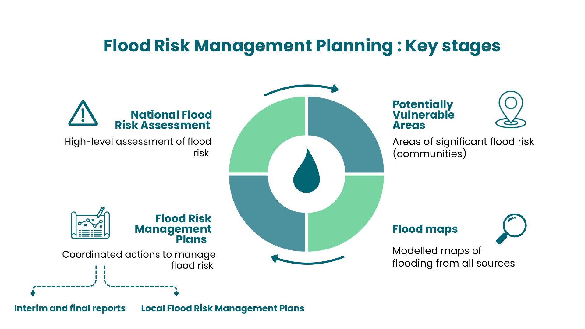
In Scotland, we use a 6-year planning cycle that enables new data, improved techniques, and developing knowledge and understanding to be incorporated regularly into the national approach. This planning framework is established by the Flood Risk Management (Scotland) Act 2009. There are several stages that work together to fulfil the requirements of each planning cycle. There are several stages that work together to fulfil the requirements of each planning cycle as shown in the diagram.
Useful information
National Flood Risk Assessment
The National Flood Risk Assessment (NFRA) provides the underpinning evidence for the risk-based approach in the flood risk management plans. The NFRA considers the likelihood of flooding from rivers, the sea, and surface water, alongside the estimated impact on people, the economy, cultural heritage, and the environment. More information is available on the SEPA website: National Flood Risk Assessment.
Potentially Vulnerable Areas
Potentially Vulnerable Areas (known as PVAs) are the places where the highest flood risk exists now or is likely to occur in the future. By identifying Potentially Vulnerable Areas, we and our partners can better target flood management efforts, ensuring we understand and prioritise where work to tackle flooding could be of most benefit. Potentially Vulnerable Areas are a vital part of protecting people, properties, businesses, communities, infrastructure, and our environment. We identify them through our National Flood Risk Assessment and we review and update them every six years. The most recent update, in December 2024, incorporated feedback from public consultation. These revised Potentially Vulnerable Areas provide the areas of focus for 2028 – 2034 Flood Risk Management Plans. More information is available on the SEPA website: Consultation on Potentially Vulnerable Areas (PVAs) for Flood Risk Management in Scotland 2024. These consultations do not cover all communities in Scotland – they relate to Potentially Vulnerable Areas only, because they are the priority areas that will be the focus of the 2028 - 2034 Flood Risk Management Plans. Potentially Vulnerable Areas were developed with community feedback.
If you have any concerns about flooding in areas outwith Potentially Vulnerable Areas, we recommend contacting the responsible authority – you can find out more on responsible authorities here: Responsibilities for flooding.
Flood hazard maps
Our flood maps are designed to help you understand how you could be affected by flooding. The maps show areas that are likely to flood from rivers, the sea and surface water. The flood maps are a public tool and used by a wide variety of people for a range of work. The maps are used as a tool for flood risk management planning to identify actions, to manage flood risk and develop plans to tackle flooding. More information is available on the SEPA website: Flood maps.
Flood Risk Management Plans
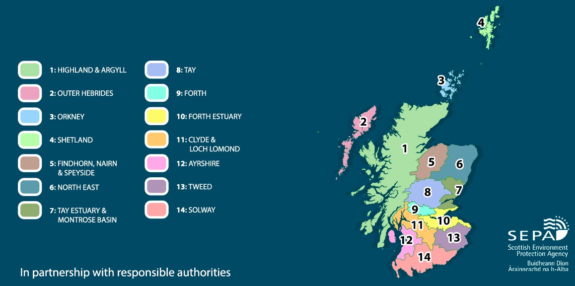
Flood Risk Management Plans (FRMPs) set the framework for how we manage and reduce the impacts of flooding across Scotland. They describe our long-term ambitions, set objectives, and identify the actions we as SEPA and our partners will take. FRMPs make sure that everyone involved in managing flood risk focusses effort where the risk is greatest and where actions will have the most benefit. Scotland has been divided into 14 Local Plan Districts, and a plan is produced for each as shown in the map below.
We review and publish the FRMPs every six years:
- 2016 - 2022 Plans were published in December 2015.
- 2022 - 2028 Plans were published in December 2021. These are available to view on SEPA’s website - Flood Risk Management Plans | Beta | SEPA | Scottish Environment Protection Agency
- We are now developing 2028 - 2034 Plans, due to be published in December 2027
How to take part
Phase 1 Consultation
Open Now
A focussed consultation on community issues, priorities and projects in Potentially Vulnerable Areas.
Phase 2 Consultation
Commencing by March 2027
A more detailed consultation on proposed objectives and actions in Potentially Vulnerable Areas, informed by the responses to the Phase 1 consultation.
Final Plan Publication
In December 2027
Publication of final 2028 - 2034 Flood Risk Management Plans